The Fal-Helford Marine Special Area of Conservation (Kevan Cook)
Saturday, 15th January 2011
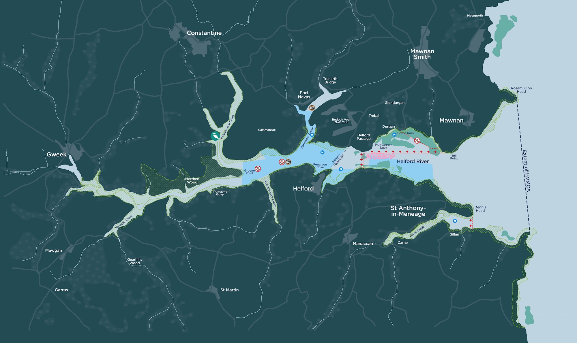
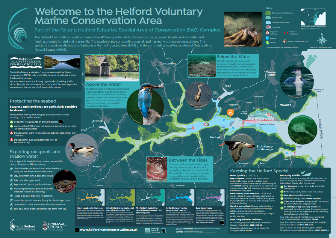
Because of its very special nature in terms of habitats, biodiversity, species, geology and scenery, the Helford River has long been recognised as worthy of protection at both European and national levels. Fortunately our speaker, Kevan Cook, Lead Marine Adviser for Natural England, was able to guide us through some of the acronyms. The Fal-Helford SAC (Special Area of Conservation), lying west of a line from St Anthony Head to Manacle Point and giving the highest level of protection, is a European designation relating to habitats and some species. It identifies the range of environments in the Helford, from the rocky shores at Rosemullion and Gillan, buffeted by strong winds and tides, passing upstream to sand banks with seagrass and maerl and then to the highly productive intertidal muds with narrow saltmarsh fringe of Polwheveral, Frenchman’s Creek and Gweek. Another European designation, though not present in the Helford, is an SPA (Special Protection Area) which safeguards the habitats of particular bird species. At a national (UK) level, the intertidal zone of the Lower Fal and Helford is classified as an SSSI (Site of Special Scientific Interest) and this overlaps with the individual SSSIs of Merthen Woods and Rosemullion Head, the latter for geological interest. Further UK designations are evolving and in course of discussion, namely MCZ (Marine Conservation Zone), MPA (Marine Protection Area) and MNR (Marine Nature Reserve). In addition, the Helford lies in Cornwall AONB (Area of Outstanding Natural Beauty), in which the emphasis is on scenic character. Through all of these, the Helford is afforded a high degree of protection. Damaging or destroying features for which a site is designated can incur considerable penalties and Natural England’s consent must be sought for a wide range of operations which might have impact, for example agricultural practice, drainage, shore work and dredging.
The Helford is blessed with a rich biodiversity. The rocky shores at the mouth of the estuary, encrusted with limpets and barnacles, have a substrate of rock and shingle which supports a variety of seaweeds, such as bladder wrack and serrated wrack, passing seawards to kelp forest growing down to depths of 15 to 18m in the photic zone. These in turn are home to invertebrates such as crabs, worms, sponges, sea urchins and bryozoa. Up-river, with less active currents, the substrate changes to sand banks, sand with rocks, or sand with mud, providing environments for beds of seagrass and small areas of maerl. Seagrasses (largely eelgrass, Zostera spp) are seasonal, underwater, flowering grasses, spreading from sub-surface rhizomes which help to stabilise the sediment. They are important protective habitats for juvenile bass and flatfish, plus sea horses. However, they are sensitive to change and can be damaged by anchoring. A current anxiety is the presence of Labyrinthula, a slime mould seen on the leaves as black spots, which inhibits photosynthesis and which has been implicated in widespread deaths of tropical seagrasses (as well as damage to golf courses!). Maerl is a collective name for species of very slow-growing coralline red algae, which secrete a hard skeleton of calcium carbonate and grow as unattached round nodules or small, twig-like, knobbly branched shapes on the sea bed at depths down to 20m. When the algae die, the skeletons build up as deposits of dead maerl with a thin layer of pink living maerl on top. The Fal-Helford SAC contains the largest maerl beds in SW England, mainly on St Mawes Bank but with smaller areas such as off Durgan. A 1978 licence from the Crown Estates Commissioners has allowed dead maerl to be dredged as a soil conditioner. However, this is a non-renewable resource. Thick deposits may have taken 8000 years to accumulate and it is a priority habitat. Many creatures live on or burrow in the beds, including jewel anemones, fan worms and Couch’s goby, but it is a fragile and easily damaged environment.
The sandy sediments at Gillan, Treath and Helford Passage contain a diverse burrowing and surface fauna, among which are peacock worm, other polychaetes such as sand mason, hermit crabs, brittle star and cockles. Shale shingle and mud from Helford Point to Frenchman’s Creek support sponges and tube worms. Shore crabs, mussels and gastropods are common around Groyne Point. The headwater creeks, such as Polwheveral and Gweek, are endowed with intertidal mudflats and sandflats which harbour amphipods, polychaete worms, sea cucumber and bivalve molluscs, creating rich feeding grounds for resident and migratory birds.
Why is protection necessary? The pressures on habitats and species are numerous and real. They include climate change, land-based pollution (agricultural and industrial), marine pollution (oils, litter), coastal development, aggregate extraction, renewable energy operations, fishing practices, aquaculture (over-stocked fish farms) and recreational use (moorings, slipways, etc). A major difficulty, unfortunately, is that the effects are largely beneath the waves and mostly unseen. For example, under climate change, sea level has risen 15cm over the last 90 years and is estimated to rise a further 1m by 2100, which will have impacts on biodiversity through altered temperatures and coastal squeeze. Increased carbon dioxide in the atmosphere has led to a more acidic ocean, making it difficult for crabs and lobsters to produce their shells. Slipper limpets, an invasive species introduced in the 1980s with no natural predators, have seen an explosive rise in population, competing with Fal oysters. (Ben Wright commented later that 60 tons of them have had to be removed from the oyster farm).
Natural England’s approach to assessing the state of the environment is evidence-based and grounded in good science. It undertakes regular transects, mapping of habitats and monitoring of species, underwater studies being carried out by divers and by an ROV (Remotely Operated Vehicle). The latter, as described in Newsletter No. 41, is a self-propelled robot with a video camera linked by cable to an onboard laptop. Funded by Natural England, it has been used by the Cornwall Sea Fisheries Committee in conjunction with ground discrimination equipment to make detailed surveys of two candidate SACs, off the Lizard and Lands End. These data sets are important bodies of information to be used in assessing proposals to create a South-West Marine Conservation Zone. The process is well underway and involves collaborative discussion by a variety of groups, such as conservationists, industry and sea users, who will submit their report to Natural England and the JNCC for onward transmission to DEFRA.
An aim of Natural England is to raise public awareness and better appreciation of our environment and the issues facing it. By engendering a sense of value and ‘ownership’ we could help to chart the way to a sustainable future. Kevan commented that, with an audience of 45 turning out on a January evening, he was probably talking to the converted. Subsequent questions, ranging over nitrates, oil spillage, bass nursery data and water quality, suggested that he was right.
The HMCG wishes to thank Kevan very much for his informative and wide-ranging talk.
