Helford’s past seen through its place-names
Places in the past were usually named in a straightforwardly descriptive way, often from the names of people who lived there. Sometimes these descriptions contain valuable clues to the botany, or occasionally the fauna, of the place when it was named. Through tracing the names in historical records we can gain an idea of how old a place- name may be, although we can never be sure how long before its first appearance a name was formed.
The Lizard district is particularly fortunate in having two charters from the Anglo Saxon period. When an Anglo Saxon king made a grant of land, the bounds of the land were often specified in detail; so we have the boundaries of six small estates in the Meneage, in charters dated 969 and 977. These estates were at Lesneage (SW7722), Penare (SW7924), Traboe (SW742l), Trevallack (SW782l), Grugwith (SW7520) and Trethewey (SW7323). The bounds of these estates can give us a glimpse of the landscape, as seen through the eyes of local people over a thousand years ago. In a few cases there are place-names of natural- historical interest.
One boundary-point appearing in the bounds both of Lesneage and Grugwith is Lenbruinn, ‘pool of rushes’ (Cornish lynn ‘a pool’ and broinn, later bronn, ‘rushes’). The larger estate of Lesneage (a name which means ‘the court of the Meneage district’) actually reached to the south of Grugwith, onto Crousa Common, so this pool may have been the large one at SW767199, though the name has not survived. The rushes may have been valued and used, perhaps for thatching or for matting, or for wicks in candles. Another pool in the bounds of Trethewey is Lyncenin ‘pool of ramsons (wild garlic)’, on the stream which forms the parish between St Martin and St Mawgan parishes, probably at SW729233. I have seen ramsons in this area. A third such pool is Poll haescen ‘pool of sedge’, on the boundary of Traboe estate, probably at SW746227, an area where David Coombe noted great tussocks of sedge. One more watery name in these boundaries is Fonton Morgeonec ‘anthill spring’ , in the bounds of Grugwith, evidently a spring distinctive for a very large anthill, or for a number of anthills, close by; this spring was probably somewhere on the stream running to the north of Grugwith. Up on Goonhilly Downs, probably near the Earth Station where five parishes meet, lay Cruc Draenoc ‘thorn-brake barrow, a tumulus either overgrown with thorn trees (probably
blackthorn rather than hawthorn, if so), or lying within a thorn-brake.
Although it does not incorporate a name, the boundary of Penare in 977 is notable because the boundary of the farm was exactly the same in 1840. This means that the hedge forming the boundary (starting at SW797242) is presumably over a thousand years old, though it may have been rebuilt, perhaps many times, during its life, and in this windswept area it certainly does not show the great variety of plant species which we might have expected.
Other names which are not recorded so early are also of interest. North of the Helford River, in Constantine parish, is the farm of Bonallack (SW7126), ‘broombrake’. (The Cornish adjectival ending – ek, often found as – ack, was used to mean place where (a certain type of) plant grows’. Another example of the same name is Menallack, in Mahe parish (SW7431). Both Bonallack and Menallack must have had considerable growth of broom-plants to have gained their names from them. Bonallack is first known in about 1250, and Menallack in 1327, so the broom-brakes must have existed in about 1200 or 1300, at the latest. Both Halliggye in St Mawgan parish (SW7123) and Halligey in St Martin (SW7323) are similarly named from patches of willows (Cornish helyk ‘willow trees’). Perhaps the most surprising name is Carplight, a now ruined farm in Manaccan parish. This name is found as Crupleid in 1199, hut the spelling Crucbleyth in 1327 gives the sense better: ‘wolf’s harrow’ (Cornish cruk ‘harrow’ and bleth ‘wolf’): the farm was presumably named from the earthwork above it (SW749237). At some time before 1199 (again we cannot know how long before) this earthwork must have been known to be frequented by wolves. Less dramatically, the farm of Carnbarges in St Martin parish (SW7424) was named from a rock or tor frequented by buzzards (Cornish bargus ‘buzzard’).
Oliver Padel
St Neot, March 2006
Bibliography
All the Anglo-Saxon charter-boundaries of Cornwall are discussed in detail by Della Hooke, Pre -Conquest Charter-Bounds of Devon and Cornwall (1994), and some of them also by Oliver Rackham, The History of the Countryside (1986).
Details of the Cornish words found in the place-names are given in O. J. Padel, Cornish Place-Name Elements (1985), and a broader introduction to Cornish placenames in Padel, A Popular Dictionary of Cornish Place Names (1988).
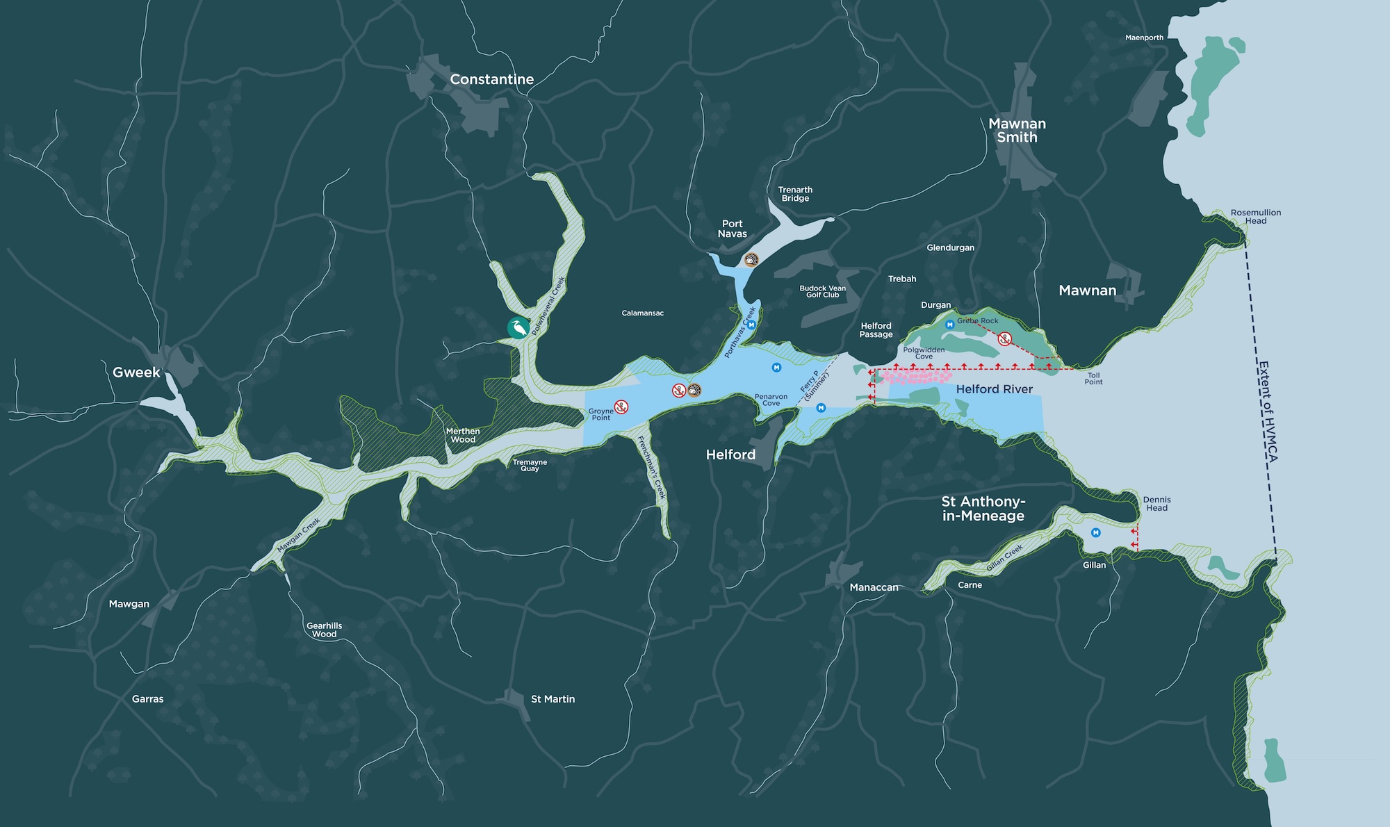
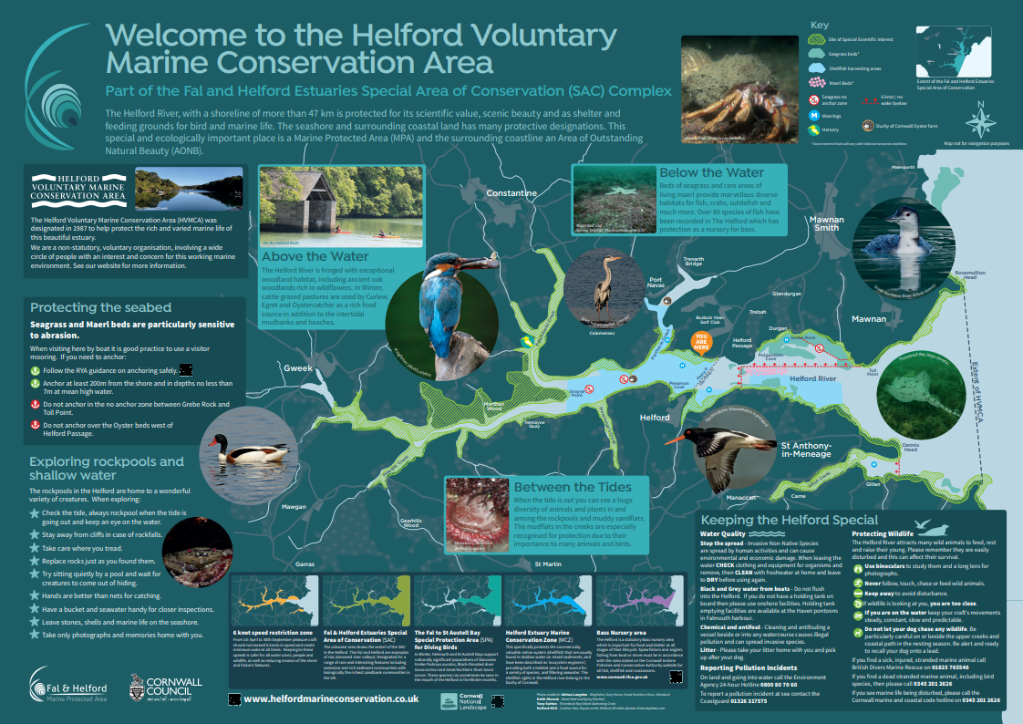
Extract from HVMCA newsletter No.33 Autumn 2006
