The Helford River Survey – 25 years on
The Helford River has long been known for the richness of its foreshores, that is the tidal area exposed between high and low water. With fully saline habitats ranging from muddy creeks to sandy bars and from low cliffs to exposed rocky reefs, the diversity of the marine wildlife is amazing and over the many years has attracted marine researchers, students, Victorian shell collectors and, more recently, seriously interested members of the public.
In the mid-1980s experienced marine biologists who had surveyed the shores since the 1940s noted some deterioration and such was the concern that moves were made to reverse this decline by designating the Helford River as a Conservation Area. Dr Norman Holme of the Marine Biological Association, Plymouth and Stella Turk, MBE, of the Cornish Biological Records Unit, University of Exeter and Cornwall County Council, led the campaign which also involved users and local residents such as Leslie Collins who later became an inspirational chairman of the group.
The first question that arose was “What is there to protect and has anything really changed?” and the sensible answer was to find out by raising funding to carry out an extensive study on the fauna and flora of the foreshores, the range of habitats with particular emphasis on the eelgrass (Zostera) beds, take account of historic data and, where possible, identify threats and make positive conservation recommendations. Problems arising from bait-digging, shellfish collection, depredations of the many educational group visitors, recreational activities, the presence of non-native species, anti-fouling on boats and general commercial usage were considered.
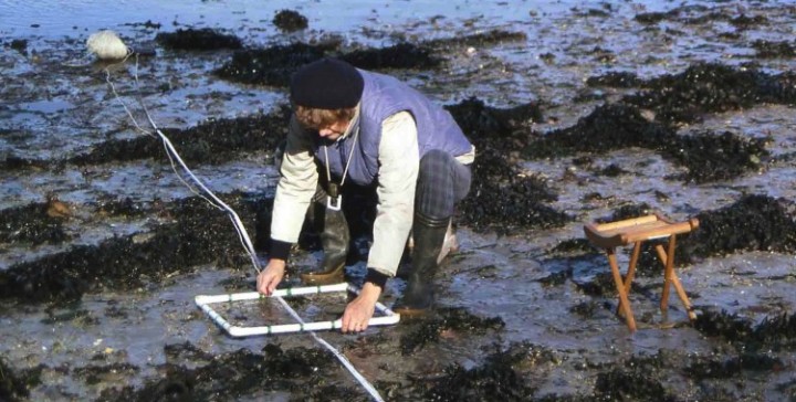 Dr Pamela Tompsett surveying a Norman Holme transect in the Helford, 1996.
In 1986 under the guidance of Norman Holme and Stella Turk, two young graduates were recruited, Roger Covey and Sue Hocking. One of their tasks was to establish the Helford River Survey choosing sites to be intensively recorded at regular intervals as resources allowed. Part of the study involved attaching a line at a right angle from the High Water limit directly down to the Low Water limit, some 50 to 250m depending on site, placing a 50cm square at selected intervals 5m to 10m and listing all living animals and seaweeds within it and also taking photographs. The length of zones and the seaweeds, animals and substrates within them along the lines were also noted.
It was important to carry this out in a non-destructive way so no digging was involved and samples removed for further identification were returned as soon as possible. The baseline report published in 1987 underpinned the designation of the Helford Voluntary Marine Conservation Area. The further work has been published as a series of reports with the latest HRS Monitoring Report No. 6, P.E.Tompsett published in hard copy and on-line in 2011 (HVMCA web site).
The nine sites chosen by Norman and Stella, reflected an interest in the historic intertidal eelgrass beds which flourished at Helford Passage Bar Beach, Treath and the Gillan inlet but these had disappeared by 1988, so, from 1996, the number of sites was reduced to six namely, Flushing Cove, Flushing Cove rocky, St Anthony, Dennis Head, Helford Passage and Treath.
I became involved with the earliest recording and subsequently led the repeat surveys in 1990, 1993, 1996 and 1999 but was not able to continue subsequently. As experts became available other species were targeted such as shore fish, bass, anemones and their relatives, molluscs – in particular cockles and eelgrass.
During the 1986 to 1999 period, changes noted included the loss of the intertidal eelgrass beds, fluctuations in the worm populations, a slight spread of non-native species and the recovery of several other species following the TBT ban in the late 1980s. The effects of algal blooms and climatic factors should not be forgotten.
It was therefore very pleasing to find that, in 2010, after a lapse of several years, enthusiastic and knowledgeable volunteers were coming forward, partly under the auspices of Abby Crosby’s Your Shore project, namely Rob Seebold and partly from group members such as the new co-ordinator Charli Marshall, to take up the challenge of recording the important marine wildlife of the HVMCA. The transect recording has already started and will continue at the appropriate low tide periods in September and possibly October.
Although the current study focuses on the existing sites it is hoped that, in future, resources will become available to target some of the other species-rich areas such as the reefs at Prisk Cove. It is planned to arrange some identification sessions in advance so that we can set up an enthusiastic and well-trained team of recorders. There is also the possibility of running a public event alongside one of the surveys.
Dr Pamela E Tompsett, Scientific Adviser HMCG
Extract from HVMCA newsletter No.43 Autumn 2011
